LEG 7 DAYS 1/2
DAY 1 EXMOUTH TO BUDLEIGH SALTERTON/OTTERTON
Boomerwalk is back! After a thoroughly soggy winter, we were keen to get back out there [not counting the recent day trip] on a proper trek. We picked a week at the end of March and decided to book up and just deal with whatever the weather may throw at us. But the first issue was simply getting to Exmouth, [bus and train, simples eh?] the bus to Bournemouth station was easy enough, and we got an earlier train than anticipated to Dorchester South. We knew we then had a ten minute walk to Dorchester West, but it took us double the time with a suitcase and stops to check Google Maps, and helpful signage only appeared when we were half way there! Our next train took us to Castle Cary, the third to Exeter St David’s, and the fourth and final one to Exmouth made for a journey rather more epic than it should be considering the modest distance involved.
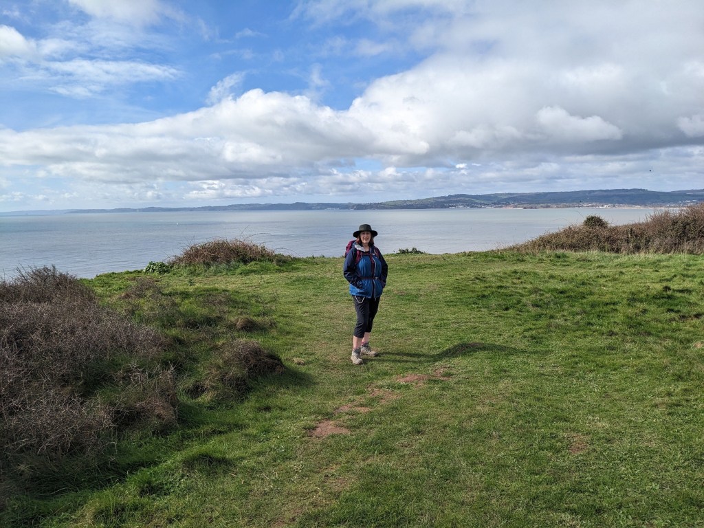
The next day was Sunday, and we started with a mooch around Exmouth marina – it was dry and sunny but with a chill in the air. It was all rather quiet along the seafront initially, with a sense of faded grandeur from the row of Edwardian villas. However, as we reached the eastern edge of town, the sandy beach was full of life; joggers, cyclists, swimmers, rowers, fellow walkers and hordes of dogs [in my voice memo I say every dog owner in Exmouth must be there – later we chatted to two locals who said that dog owners travel miles, even from Bristol, to walk their pets on Exmouth’s sands]. Although not yet Easter, there were facilities catering to the crowds, cafes, ice cream and toilets, though we weren’t ready to stop yet having barely got going!
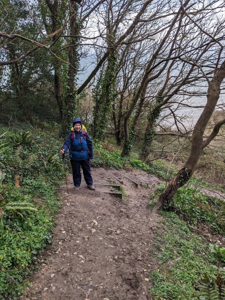
At the end of the beach we got our first look at the cliffs with their distinctive deep red colour, quite a contrast to the chalky limestone cliffs we’d walked in Dorset. A zigzag path took us up to the top, where we came upon the Geoneedle, a means of showing the different rock strata, but today was encircled by a group of Spanish teenagers, presumably on an educational trip. We took in the view of Exmouth, and in the distance, we could see the next stretch of Devon’s coast that we plan to tackle, designated “strenuous” by the guide book, with some days where we will have to walk at least eleven miles [gulp]. For now, our immediate problem was the state of the path – thick, sticky, slippery mud. We walked at the side as much as possible, but risked sliding into the path proper, and as our boots were in a mess already, we just had to walk through it, even the waterlogged sections. Paul’s boots are waterproof, but mine have a breathable upper, so if my feet sink too deeply, water can seep in.
Sandy Bay holiday park was earmarked as our lunch stop. Before entering, we cleaned off our boots with the Boot Buddy, so felt half way respectable as we sat down for a civilised lunch plus gin and tonic! We had to deal with some hills as well as the mud, so a good rest was welcome, as the restart had more of the same, except the path became stonier alongside the mud. It also got rather close to the cliff edge on occasion, but at least the wind was gentle today. The clouds had increased, and the mood was definitely gloomier than at the outset, but we were still dry. I kept expecting to see a view of Budleigh Salterton, but the path veered inland through woodland, and we could see nothing until we emerged into the town itself.
We had failed to find anywhere to stay in Budleigh, but there was a nice pub in nearby Otterton called The Kings’ Arms, and we had time for a quick coffee before catching a bus to get there. Over dinner, we reflected on a great start to the week!
DAY 2 BUDLEIGH/OTTERTON TO SIDMOUTH
What was I just saying about a great start? How the world likes to make fools of us! Monday morning we were waiting at the bus stop for a ride back to Budleigh – waiting, waiting and more waiting. There was no signal, so we couldn’t track the bus and after fifty minutes, we came up with Plan B; walk out of Otterton and alongside the river on a path to the coast, about half an hour in all. This would bring us just to the east of Budleigh, so not missing much, except the opportunity to have my Coast Path Passport stamped. [Major digression and whinge now: I have been very unlucky regarding stamps to date. This is a scheme run by the Coast Path Association where various organisations along the Path can stamp your booklet and you mark the date and location as a nice little record of your jaunt. But Swanage Tourist Info Office has been closed at the time we’ve been there, Chesil Beach Cafe was closed for the Queen’s funeral, West Bay Tourist Office didn’t open until 11am and we needed to set off at 10am, and now, I had passed up the chance to get to the shop in Budleigh the day before as our boots were in a dreadful state and I thought it would be easy to pop in the next day. Aarrgghh!]
At least it was easy going on a proper path, during which time we heard both an owl hooting and a woodpecker drilling. The river Otter is evidently a good spot for twitchers! As we neared the coast, we first had to head west through grassy fields before rounding the headland. There was a cold wind which hit us at the more exposed points, and we were walking uphill for the most part, but the grassy terrain was bliss compared to yesterday’s mud. We reached Brandy Head Observation Point, a small building with benches outside for a welcome rest. It was used for operations in WWll, but derives it’s name from much earlier smuggling activities. [I think smuggling will be a theme throughout the south west!]. We were now getting some lovely views of the red cliffs which represent the Triassic period, even older than the Jurassic which gives its name to the entire stretch of coastline between Exmouth and Poole given World Heritage status. An even lovelier sight was the convenient holiday park where we would have another civilised lunch [though the gin and tonics were an eye watering price!].
Whereas there had been periods of sunshine yesterday, today the full cloud cover made for a gloomy atmosphere and chilly conditions, though whilst walking we were warm enough. The path angled inland and upwards through woods, and there was plenty more mud, though the myriad tree roots gave our feet some purchase. When we emerged from this section we could see Sidmouth in the valley below, and beyond, the ups and downs we would have to tackle the next day. First was the descent into town, through a grassy area that serves as a garden of remembrance, with benches, plaques and flowers dedicated to loved ones. On the edge of town, we passed two rather grand hotels harking back to the Edwardian era, but Sidmouth is still popular, the place was buzzing with crowds enjoying its genteel seaside charm even though we were ahead of the school Easter break. We aimed for the Dukes Inn, where we planned to have a drink and get the passport stamped [we could have stayed there too, but it was quite pricey, so we had opted for an AirBnB room instead]. Unfortunately, Dukes was closed, and I was bemoaning the curse of the passport, when we were directed to the Elizabeth hotel next door – the receptionist there was very helpful and actually went into Dukes to find the stamp for me [I think they must have the same ownership]. As we threaded our way through the town to our stay, we stopped to buy sandwiches for the next day – I had the feeling tomorrow’s lunch would not be such a comfortable affair, the weather was beginning to worsen. Wind, rain, and heavy fog awaited – find out how much we suffered in the next post!
LEG 7 DAYS 3/4
DAY 3 SIDMOUTH TO BRANSCOMBE
As well as my photos, I record voice memos to remind me of our walks, but replaying today’s notes, I struggled to hear my voice over the sound of the howling wind. Sidmouth was grey and gloomy as we started our first ascent out of town. The terrain was still muddy, but the fields still had a fair covering of grass offering some purchase, and typical coast path steps with wooden risers in super steep sections. What we were really fighting though was the gusting wind – I hope to post my video of Paul, as you can’t get any sense of the wind’s power from my pics.
After a tough time getting up to the cliff top east of Sidmouth, we enjoyed a respite from the wind as for a while we were sheltered by trees. This was only too brief though, because soon we were facing the multiple hazards of slipping on mud, close to the cliff edge, while exposed to the wind again. A steep set of steps took us back down to sea level at Weston Beach, where we sat on some broken slabs for the second worst picnic ever [see the Kingston to Kimmeridge blog for the league topper]. Sandwiches accompanied by lashings of cold rain to the soundtrack of the surf crashing against the shingle – it felt wild and lonely, though I suppose we’re never too far from civilisation!
Following lunch, I experienced one of the least dignified moments of my entire life, and as this is a warts and all account, you won’t be spared either! The beach was deserted, so Paul had no problem relieving himself, and I thought I would attempt an al fresco wee for the first time in years.
It’s a little more complicated for us ladies to accomplish if we want to keep our clothes dry, and of course I was wearing a triple layer of pants, trousers and waterproofs! I hunched down in a gap in the undergrowth, but I simply couldn’t squat long enough to succeed [my knees are a particular weak point]. Then Paul spotted a square of porcelain with a rounded rim on the edge of the beach that had been used for a campfire. He thought it might be easier for me to perch on the edge as if to imitate a proper toilet. A good theory, but a complete failure in practice, and to add insult to injury, I now had a dirty bottom from the cold ashes! At this point I decided to brush off the ashes and give up, which was just as well, as a couple and their dog suddenly appeared from the path at the other end of the beach. My only consolation is that at least I wasn’t caught in flagrante by a member of the public!
We carried on in the light but persistent rain, ascending from the beach. Below we could see the surf throwing up piles of creamy foam onto the shingle. My memo refers to the path as “treacherous” and Paul nearly fell in one place. We really did try to stay upright to avoid injury and getting any muckier than we already were! The track eventually got easier as we approached the village of Branscombe where we would be staying, and we could see our target nestled in a valley, slightly inland. We arrived at The Mason’s Arms about three o’clock, and were thrilled with our room. A lovely double bed, huge bathroom with separate bath and shower, and a lovely meal in the pub later. Highly recommend it for a stay and/or meal if you’re in the area.
DAY 4 BRANSCOMBE TO SEATON
We awoke well refreshed after our luxurious night, looked outside to check the weather, and couldn’t see very far! Fog had descended, but at least it wasn’t raining, and we only had a short distance to walk today. We had decided to have an easy day before tackling the famous undercliff between Seaton and Lyme Regis.
Above Branscombe Beach, there was a difference of opinion between our trusty App, Komoot, and the official coast path signage. Routes do get changed and it’s impossible to tell which is the “correct” path, but this time Paul insisted on following Komoot, which was the steeper route! Looking back at the map, we simply walked over the top of Hooken cliffs rather than walking through the undercliff. Visibility was dreadful on top of the cliffs, the wind was so strong we had difficulty keeping our footing, and I was relieved to see that, unusually, there was a fence marking the edge of the cliff. No distant views in today’s collection of photos.
Incredibly, when we reached Beer Head, weather conditions were much better as I described it as “peaceful” and instead of raging wind as the background to my voice memo, there are birds tweeting. We could now actually see the path ahead, and the village of Beer in the valley. [I have a soft spot for Beer, as we visited the quarry caves there on our first day as an engaged couple.]
We stopped at The Anchor Inn for a coffee, but by the time we’d finished, it was lunchtime, so we stayed put and ordered food. We had a little stroll around Beer, but it then began to rain quite heavily, so we headed off for the final stretch to Seaton. After another uphill climb in the legs, I was decidedly miffed when we walked especially around the town to find the Tourist Information Office to get my Coast Path passport stamped, only to find it closed at 1pm instead of the advertised 3pm. I really had bad luck with these stamps on the Jurassic section! [I had much greater success on this latest South Devon leg.]
The next day we would face the famous Undercliff, but first we would have to find somewhere to eat in sleepy Seaton…
LEG 7 DAY 5 SEATON TO LYME REGIS
It’s not often you see a walk that comes with it’s own special warning, but that is what greeted us on the outskirts of Seaton: “…it takes approximately 31/2 – 4 hours to walk to Lyme Regis. The terrain can be difficult and walking arduous.” So what exactly were we facing? An eight mile stretch, with no access inland or to the beach throughout, the only entry points at either end. Once committed, you have to keep going all the way through! The Undercliff was formed by repeated landslides, most famously on Christmas Day 1839, when a chasm was created, leaving an outcrop now known as Goat Island. Over the ensuing decades the unusual topography has created a unique habitat, which has been described as the nearest Britain has to a rainforest. [I’m not entirely convinced, but, to be fair, on this day it was both rainy, and foresty…]
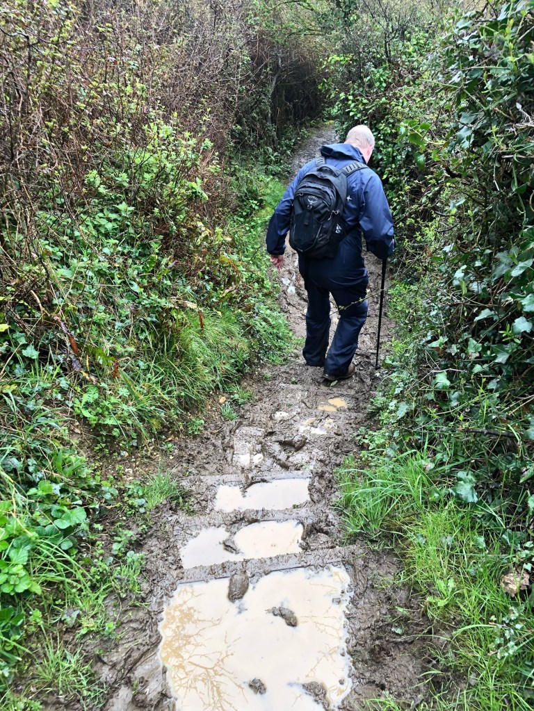
First though, we had to depart sleepy, grey Seaton. It’s a similar size to Sidmouth, but so different in feel; whereas the latter is lively, with plenty of tourists despite being so early in the season, the former feels like a place on its last legs. We’d felt lucky to find an Italian restaurant open to have dinner the night before, and now, on a dull morning, it looked even more grim. We stopped to buy sandwiches for lunch, then crossed the concrete Axmouth bridge, before a steep road took us up to a golf course. We skirted a few holes on our way to the cliff top where we came across the sign pointing the way ahead, along with the warning! The danger felt a bit exaggerated as we strolled along past fields on level ground whilst the sun made a brief appearance, but it wasn’t long before we were treading carefully. On a sloshy, muddy track, we usually try to walk on the side, but this does leave you liable to sliding into the centre, even with poles to assist, so, as falling over would leave us miserably filthy, we had no choice but to march straight through the middle of the muck. My walking shoes are breathable, which basically means they have holes in the upper, so as I sunk deeply into the slosh, I was sure that my socks were soaking up some of the liquid.
Before long, we reached the start of the woodland, descending via steps into the chasm. The path twists and turns, up and down, meandering through the habitat, and it was all rather peaceful; the trilling of birds, the roar of the surf, and the squelching of our boots! We stopped for a water break on a pair of logs and surveyed the clumps of mud sticking to our shoes. It was the kind of walk where we were having to concentrate, not just due to the slipperiness, but also looking out for tree roots, ducking under low branches, and the overall variation of the track. We should really have done this on a warm, sunny day when dry ground and the forest shade would have been just the ticket!
We hadn’t seen a soul for the first couple of hours, but all of a sudden, there were fellow walkers both behind, and approaching us. As the path was fairly narrow, we had to adopt the pedestrian version of passing places on country roads, squeezing into the undergrowth. Still, it was nice to pause for a friendly chat to exchange information about conditions on the path. Although the ups and downs aren’t especially severe compared to the Coast Path generally, we did hit one set of steps that had me gasping, and as there was a bench at the top, we took this opportunity to stop for lunch [though we then had the embarrassment of watching others toil towards us while we hogged the resting place, oh well, first come first served!].
There is one part where there is a brief respite from the closeness of the forest, and a hint of civilisation; an open area a where you can see an old pumping station and engineer’s house with the remainder of the road that once provided access. But soon, we were back to the forest, with a You Are Here sign showing us our progress. We had broken the back of it, but my voice memo describes the last part of the Undercliff walk as “punishing”, the mud sapping all the energy from our legs, meaning The Slog started earlier than usual. [The Slog is our name for the final one or two miles, when the end isn’t TOO far away, but mentally you’re thinking you’ve had enough for the day!] We emerged from the Undercliff about two o’clock, which meant we had covered it in just under four hours, which I thought was not too shabby, taking the conditions into account. However, we still had another mile and a half to get to our stop at The Pilot Boat in Lyme Regis.
We got as far as the Cobb [famously featured in The French Lieutenant’s Woman, and any version of Jane Austen’s Persuasion] where we were able to clean up our boots in the public toilets. Though it was a pretty dull day in March, there was still plenty of tourist activity in Lyme, so Paul had an ice cream and I enjoyed a cup of mulled wine. These are the moments when we sit down, a bit tired, sweaty and dishevelled, but feeling rather pleased with ourselves for having achieved our goal, and that our pub dinner will be well earned. The extra reward today was the knowledge that this walk completed the Jurassic Coast section of the Path. Little did we know it would be October before we strapped on the rucksacks again, but at least we would be blessed with summer weather, [of the kind you dream of during the actual summer!] so all we had to worry about was our first Expert level walk. I promise not to keep you waiting too long for the first report of Leg 8!
LEG 8 DAY 1 SALCOMBE TO EAST PRAWLE

Just what was it about Salcombe in Devon that made us select it as our next start point, I mused, as I sipped my favourite Salcombe Gin and tonic in the bar at Salcombe Distillery? [Feel free to offer an answer in the comment section!] Liquid refreshment aside, it’s a charming place overlooking an estuary. I had wanted to stay at one of the pubs in town, but they were rather expensive, so we had opted for an AirBnB called The Fo’c’sle, not too far away. It was down hill into town but a steep walk back on a full stomach! [Steep was a recurring feature of this leg.]
Logistically, we had had to be creative in our planning; public transport had sufficed to get us about on the Jurassic Coast, but we were now getting further afield. My solution was to drive to a long stay car park at our end point, Exmouth, and use public transport to get to Salcombe, gradually walking eastwards until we got back to our car to drive home on the final day.
Our second issue was that we hadn’t been able to find anywhere to stay at the end of our first day’s walk, so we decided we would call a taxi to get us back to Salcombe for another night, and return to East Prawle the following morning to continue.
You may recall that aside from June, we didn’t have much of a summer in 2023, but the weather gods must have taken pity on us, for they granted us a glorious last blast of sunshine in October. By sheer chance, we had selected this week for our walk, so we set off on the first morning wearing shorts, sun hats, and big smiles. We bought a chicken Caesar salad for lunch at a deli in town, and headed for The Ferry Inn [a popular name for pubs in this area, with good reason] beside which we would catch our very first ferry along the Coast Path. Devon has a great many inlets and rivers, so crossing water would be a regular feature! Our first boat was small and open, like a rowing boat but with a motor, which took a mere minute or so to reach the other side. A rather lovely start to the walk was swiftly followed by our first ascent through East Portlemouth on a good path until we hit Mill Bay, a virtually empty beach, next to which were to be found Toilets [I get overly excited at the sight of public loos on these walks!] which I made use of before we continued into woodland.
The next stretch was very pleasant, we ascended under the cover of trees, with glimpses of the estuary below, where people were swimming, fishing and sailing, making the most of the gentle waters and sunshine. We emerged from the woods to a great view over the estuary, walking on a carpet of autumn coloured leaves, on a good path, except for it getting very close to the cliff edge and giving Paul a few collywobbles. [Nothing to be done but face the fear in the circumstances!] The path then became more difficult; we weren’t walking but scrambling – this is the term I use to describe it when rocks are embedded in the ground and you have to pick your way carefully along. I’ve included a photo of a scrambling section from day two below to give you an idea of the terrain. We were passing some rather dramatic rock formations; unlike Dorset, which has mainly white limestone cliffs, and east Devon where they are a deep red colour, these were mostly dark grey or even black [probably somewhat creepy on a wet, gloomy day].
As there were plenty of them about, we selected a rock to sit on for lunch and made sure to drink plenty of water, as I had sweated fairly freely; it wasn’t just sunny, it was actually very warm. We had just over three miles to go, and while it hadn’t exactly been a doddle, we were feeling pretty comfortable about reaching our end point in the village of East Prawle in good time. I say the village, actually we were aiming for The Pig’s Nose, a pub which is very well known locally, practically every walker we spoke to was heading there too!
We had a rest at the coastguard station at Prawle Point, the most southerly part of Devon, before we tackled the last stretch of coastline for the day, nice easy going on grass. It was when we turned inland to the village that I really felt the lack of walking practice though; going uphill always makes me gasp, and it was steep pretty much all the way to the pub! First of all up a stony track, and then up a grassy field, where I had to take not just one, but three breathers, [next day I took a photo of Paul as we went back down, but it doesn’t look overly steep at all in the pic!] and then onto the village road, ascending all the way to the pub benches. We got there at half past two, a great result, as the pub was closing at 3pm. We did indeed meet up with our fellow walkers there: I was telling them how we had only just managed to order a meal the night before as the pub stopped taking orders at 7.30pm. “Welcome to Devon” was the deadpan response! We had time enough for a drink and to make use of the facilities, [or “facilitaaays” as Paul insists on saying] while Paul started ringing local taxi services. There followed a nervous time as the first two calls couldn’t, or didn’t want to, come out to us. When deciding on this plan, we had overlooked the fact that the estuary goes quite far inland, so it is a long drive around to get back to Salcombe. Fortunately, someone did agree to collect us, and we just had to suck up the fare of £50. We booked the same service for the next morning, another £50 thank you very much – although it was nice to have another night in Salcombe, it would have been better to have gone eastwards. Oh well, never too old to live and learn!
All in all, it was a great start to the week. Lovely weather, moderate level walking and an early finish!
LEG 8 DAYS 2/3
DAY 2 EAST PRAWLE TO TORCROSS

Day 2 would begin with a taxi ride back to East Prawle, so Paul firstly popped up to the nearby Spar to buy lunch, then we were off. Half an hour later, we were in the centre of the village, before retracing our steps from yesterday [downhill this time] to pick up the Coast Path. It was all very tranquil and easy, level and grassy underfoot, so we had a nice warm up before we hit a section scattered with rocks, which entailed scrambling rather than walking. I explained all about scrambling and included a photo in the Day 1 blog. We encountered a few short steep sections, but nothing too difficult, and an hour later we were having a break at Lannacombe Bay.
The going continued in a classic coast path style, fields on one side, a cliff top track, and the sea below, so we were able to make good progress. We had a bus to catch later, so it was good to reach Start Bay by noon. We could see the lighthouse at Start Point, but we had our first hard graft to get there; more scrambling, which evolved into rock climbing as we made our way around the cliff face, in weather I described as “scorchio” in my voice memo! We had a brief respite at the lighthouse as we followed a tarmac path up to a car park, where we joined other people picnicking [except we didn’t have chairs or a rug, we just plonked ourselves on the grassy knoll] and ate a disgusting couple of sandwiches and a horrible sausage roll. The best I can say is that they filled a hole!
There were a few more small ups and downs next, but we could see the hamlet of Beesands ahead [I say Beesands, I actually mean The Cricket Inn] where we stopped for a refreshing gin and tonic. We had only just resumed when we passed a kiosk, and as the sun was still shining strongly, we had an ice cream as well! After being down at sea level, we did have one more headland to negotiate, along a path through woods, mostly uphill via a series of steps. At the peak, we had a good view of Torcross, a small strip of land with the sea on one side and a lagoon on the other. We reached the village at three o’clock, and watched some swans while we anxiously awaited the bus expected at twenty six minutes past [on the last leg, you may recall a bus never turned up]. With much relief, the bus arrived on time, and before long we were settled in our AirBnB enjoying a cream tea, and reflecting on a good day, aside from the lunch!
DAY 3 TORCROSS TO DARTMOUTH
I can guess what you’re thinking dear readers-why hasn’t anything gone wrong yet? Where are the usual tales of woe? Crazy weather, getting lost, getting hurt [or all three!]? Well, the first hiccup occurred this morning; there was no breakfast at the AirBnB, but there was a cafe by the bus stop in Torcross, so we planned to have a coffee and pastry there. Alas, it was closed, [it had been open the previous day] a sign saying it’s only open Friday to Sunday. There was a pub a bit further on but that didn’t open till eleven o’clock. On the bright side, there were some public toilets at the end of the village [a sight guaranteed to cheer me up!] where there’s a car park, and a tank on display. Yes, you read that right! Actually, it was featured on Michael Portillo’s programme about the Coast Path-it sunk during practice for the D-Day landings and was recovered by a local in the 1970s.
Leaving Torcross, we had the opportunity to get a couple of miles behind us at the cost of expending little energy, as we walked along the level spit between the sea and and the lagoon [though Paul moaned about it being boring, you just can’t please some people!]. To our delight, at the end of this section, there was a open kiosk on the beach, so we had a belated coffee and cake, and as we crossed the road to continue, double delight, there were more toilets.
There followed our first sustained, steep section of the day, heralding the return of the gasp. However, I felt by this third day, my fitness had already improved. The ascent continued all the way to the village of Strete. Descending can be just as difficult though; we had to negotiate a vertiginous down and up, reminiscent of the steps near Chapman’s Pool, but just grass here. Thankfully, the ground was dry, I can’t imagine how we would have coped in the conditions we had in March. For once, I think my photo does represent the challenge. We took it very steadily down, making the knees work hard. Paul likes to walk across the slop, as if skiing, whereas I prefer to sidestep. Having achieved height again, we could see Blackpool Sands ahead, where we planned to stop for lunch [no manky sandwiches today] but as we got nearer, the beach disappeared from view, and we found ourselves on the wrong side of a fence, worrying we might have missed the cafe. Of course, it was simply further on than we anticipated! It was lovely to sit at a proper table, overlooking the beach, while awaiting our freshly cooked food. I also got the passport stamped here. We were just slightly short of the five mile half way mark, but it was only half past twelve, so we were making good time.
The afternoon saw more ascending of a steady nature, and a course that took us inland to the picturesque village of Stoke Fleming, where a good stretch of tarmac is always a nice respite from uneven terrain. When we found ourselves back on the coast, the open grassy ground soon gave way to woodland, which offered welcome shade from the sun. The path meandered up and down, and I kept expecting to see Dartmouth Castle, but we had to reach the mouth of the River Dart estuary before we caught a glimpse of it. We had the “so near yet so far” feeling then, as we knew our target was close, but it still seemed to take ages to get there! The legs were getting tired, so it was good to stop at the Castle cafe for a cup of tea. I say castle, but there isn’t a lot remaining to be honest, one tower, and remnants of fortifications on either side of the river.
The last mile or so can be a slog, but we were now on proper roads or paths as we walked alongside the river towards the centre of Dartmouth. It was a charming scene, with boats on the water, the sun shining, and an imposing building I took to be the Royal Naval College in the distance. We arrived at the Seven Stars pub around half past three, where I had the opportunity to assess my feet. I had put a Compeed plaster on my right little toe, but a blister had still formed and the plaster had ruckled up, so I decided to remove it and try covering it with just the zinc oxide tape the next day. We had a tough day ahead, in terms of mileage and steepness, so I needed to protect the toe as much as possible. Weirdly, the fourth toe on my left foot that gave me all the trouble in March was absolutely fine, as was my entire left foot!
So, the main story of this post is one of ramping up the difficulty and distances, but very little drama so far. The next day would really test our bodies though-keep a look out for how we managed our first “expert” rated walk!
